10:10 P.M. UPDATE:
BREVARD COUNTY, Fla. — The National Weather Service in Melbourne has issued a tornado warning for Central Brevard County in east central Florida until 10:30 p.m.
10:00 P.M. UPDATE:
A Flash Flood Warning has been issued for central and northern Brevard County until 11:45 PM.
This includes Rockledge, Cocoa, and Cocoa Beach.
Doppler radar estimates 7-12” of rain has fallen in this area.
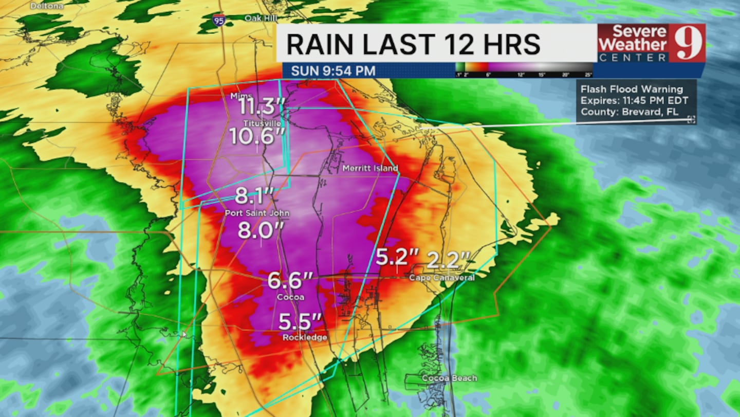
An additional 2-3” of rain is possible this evening.
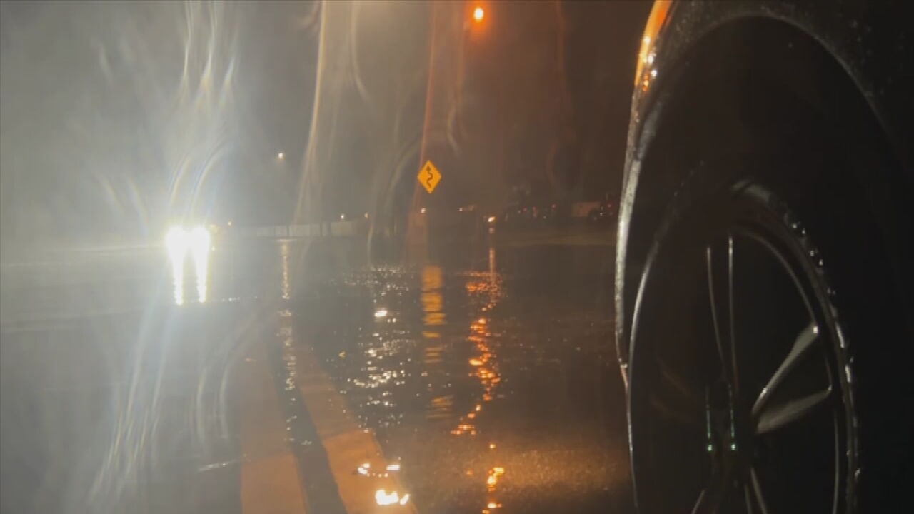
Law enforcement is reporting flooding in this area.
A Flood Watch continues for much of Central Florida through late tonight.
Stay with Severe Weather Center 9 for the latest.
PREVIOUS STORY:
9:45 UPDATE:
Flash Flood Warning for northern Brevard County has been extended until 10:45 PM.
Doppler radar now estimates 10-13” of rain has fallen in this area.
An additional 1” of rain is possible.
Widespread flash flooding is being reported across much of Titusville.
8:30 UPDATE:
A Flash Flood Warning has been issued for central and northern Brevard County until 10:00 PM.
This includes Rockledge and Cocoa.
Doppler radar estimates 3-5” of rain has fallen in this area.
An additional 1-2” of rain is possible this evening.
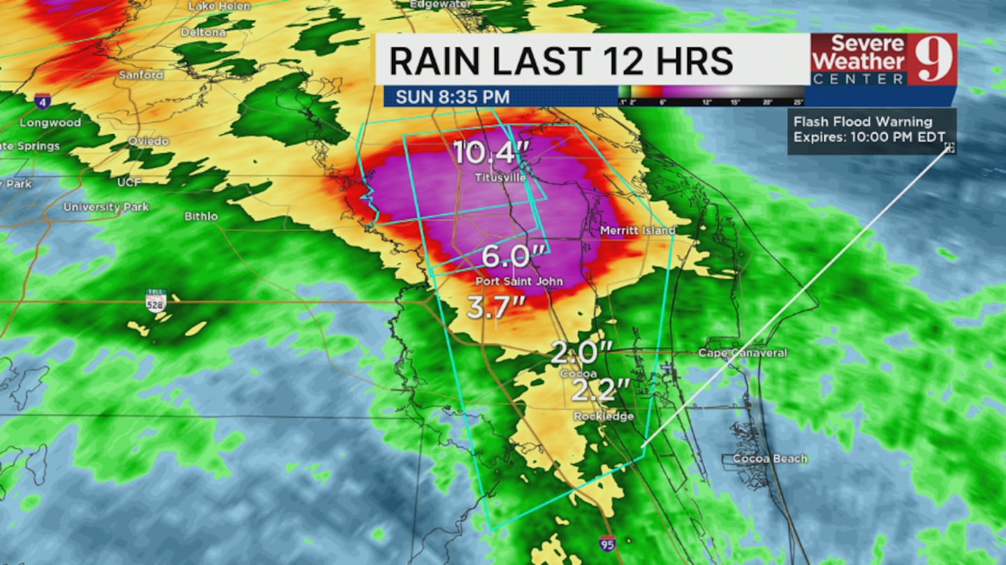
Flash flooding is likely or is ongoing in this area.
A Flood Watch continues for much of Central Florida through late tonight.
Stay with Severe Weather Center 9 for the latest.
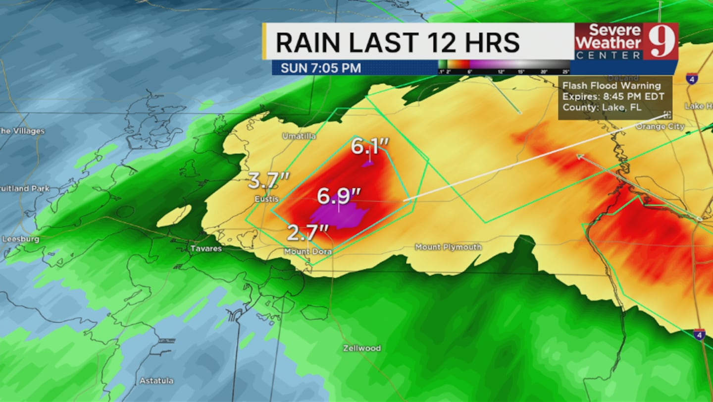
8:00 UPDATE:
A Flash Flood Warning has been issued for northern Lake County until 10:00 PM.
This includes Eustis, Tavares and Mount Dora.
Doppler radar estimates 6-9” of rain has fallen in this area.

An additional 2-3” of rain is possible this evening.
Flash flooding is likely to occur or is occurring in this area.
A Flood Watch remains in effect for much of Central Florida through late tonight.
Stay with Severe Weather Center 9 for the latest.
7:30 UPDATE:
A Flash Flood Warning has been issued for northern Brevard County until 9:45 PM.
This includes Titusville, Mims and Port St. John.
Doppler radar estimates 7-10” of rain has fallen in this area.
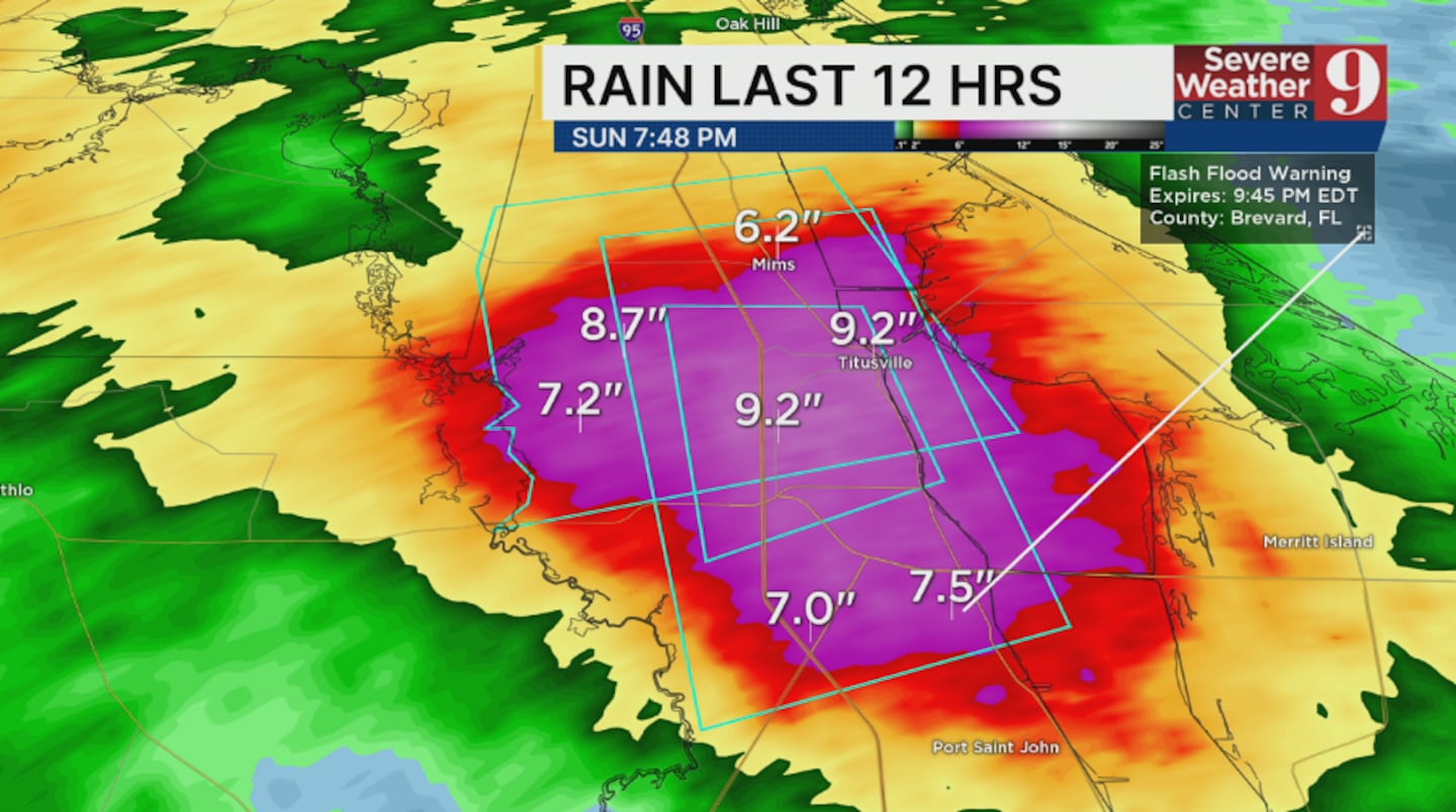
An additional 2-3” of rain is possible this evening.
Flash flooding is being reported by law enforcement in this area. Multiple streets are reported closed in this area.
A Flood Watch remains in effect for much of Central Florida through late tonight.
A Flash Flood Warning has been issued for northern Lake County until 8:45 PM.
This includes Eustis and Mount Dora.
Doppler radar estimates 3.5-5.5” of rain has fallen in this area.
An additional 1-2” of rain is possible this evening.
Flash flooding is likely to occur or is occurring in this area.
A Flood Watch continues for much of Central Florida through late tonight. Additional flooding is possible through this evening.
Stay with Severe Weather Center 9 for the latest.
6:15 P.M. UPDATE:
A Flash Flood Warning has been issued for northern Brevard County until 8:00 PM.
This includes Titusville and Mims.
Doppler radar estimates 3-5” of rain has fallen in this area.
An additional 1-2” of rain is possible this evening.
Flash flooding is likely to occur or is occurring in this area.
A Flood Watch remains in effect for much of Central Florida through late tonight. Additional flooding is possible through this evening.
Stay with Severe Weather Center 9 for the latest.
5 P.M. UPDATE:
A flash flood warning has been issued for east central Brevard County until 6:45 PM.
This includes Titusville and Port St. John.
Doppler radar estimates 3-5” of rain has fallen in this area.
An additional 1-2” of rain is possible this evening.
Flash flooding is likely to occur or is occurring in this area.
A Flood Watch remains in effect for much of Central Florida through late tonight. Additional flooding is possible through this evening.
Stay with Severe Weather Center 9 for the latest.
Click here to download our free news, weather and smart TV apps. And click here to stream Channel 9 Eyewitness News live.

©2025 Cox Media Group